One of the biggest challenges to cattlemen across the country is drought. Most cow-calf producers rely on pasture to feed their cattle, and when that pasture isn’t available, many cattlemen must cut back on their numbers.
Preparing for these natural disasters is hard to do, but a new partnership between the USDA and NASA can help ranchers do just that. The partnership, which was announced on July 16, will give the USDA access to soil moisture maps, which can help producers predict drought.
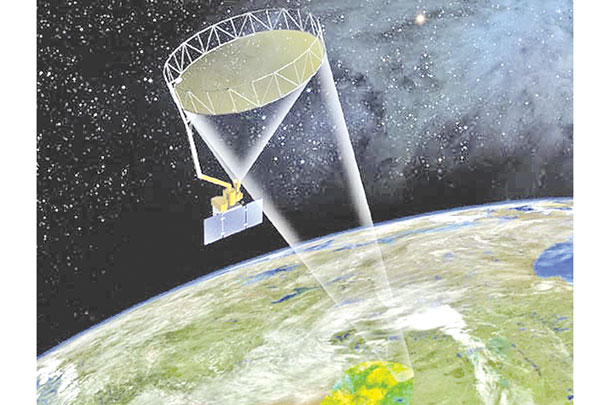
One of the satellites that will be used to create these soil moisture maps is the Soil Moisture Active Passive (SMAP) satellite, which measures how much water is in the top 2 inches of soil all across the U.S. and even across the globe. SMAP was launched in January 2015 on a minimum of a three-year mission and currently produces a composite map every two to three days.
The data these maps provide can be used by producers for flood mitigation, drought status and watershed management, according to the USDA.
The Gravity Recovery and Climate Experiment (GRACE) satellites, which were launched in 2002, help create current soil moisture maps. These satellites detect small changes in Earth’s gravity field, which are caused by water redistribution beneath and on the surface.
The satellites are a pair, travel approximately 137 miles apart, and the changes they record help create the data then used to create the maps. Computer models use long-term meteorological data, including solar radiation, precipitation and temperature, along with water storage measurements from GRACE to create the soil moisture maps.
GRACE is also used by the U.S. Drought Monitor, which creates maps every week depicting the current drought situation.
“We use several programs to create the drought monitor, including GRACE,” says David Simeral, associate research meteorologist, U.S. Drought Monitor and Western Regional Climate Center, and one of 11 authors for the national drought monitor.
He explains how they also use a program called NDVI, or normalized difference vegetation index. “Over a period of time, like today, a satellite looks at bands that are green and can record how green it was on that day. It creates a period of record. It then looks at deviations from greenness on that particular day in the past. This program is only good seasonally, however, as things start to get brown out West this time of year.”
He adds, “We look at it a lot in the spring and the summer. It is a satellite-derived product that we use.”
The NDVI could also be utilized by the USDA to see potential yields on crops, and to see what areas of the country have greener areas and where it is not as green. Satellites have the opportunity to picture wide areas of land, creating bigger overall pictures for producers and for scientists to analyze.
VegDRI
Another program that utilizes satellites is the Vegetation Drought Response Index (VegDRI). This tool creates maps used for drought information. They are produced every other week and combine climate-, environment- and satellite-based observations.
“The strength of VegDRI is its ability to integrate various drought indicators from satellite, climate and environmental observations and identify patterns and relationships among different variables.
VegDRI provides federal and state agencies, as well as individuals, with timely and accessible local drought maps to assist in management decisions,” according to the U.S. Geological Survey.
VegDRI is heavily utilized by the U.S. Drought Monitor to create their weekly drought updates and could be used by producers to monitor current vegetation in their area.
Knowing potential drought challenges can help producers to make management decisions early on – before a market is flooded with producers selling off their cattle. It can also help producers to make decisions on how long to keep cows and calves on certain pastures, preventing overgrazing.
It can also help ranchers to plan when they need to plant or harvest, if they have a diversified operation. Soil moisture improves weather forecasting and climate modeling, according to the USDA.
Wildfire detection
Another area where the partnership will benefit cattlemen is in wildfire detection. Under the new agreement, the USDA now has expanded access to data from NASA satellites that will help Forest Service firefighters and first responders better detect wildfires and predict their behavior.
The USDA and the Department of the Interior have spent nearly $1.5 billion annually over the past decade on wildfire suppression, but this new technology has the potential to stop wildfires before they start, saving money, land and even lives, according to the press release.
“Fire can not only be severe because of drought, but you can also have bad wildfire seasons when it’s wet too due to more vegetation. We keep an eye on that kind of stuff,” says Simeral.
Satellites that determine vegetation conditions help to produce daily information that shows what the outlook is for potentially large fires. Fuel mapping can be created by taking 20 geospatial layers, which describe disturbance, vegetation, fire and fuel regimes to show where the most fuel for a fire is located.
Controlled burns could be used to help reduce the risk of fires in areas with excessive fuel, helping to control the effects of uncontrolled fires.
This information can be used by ranchers to be prepared for range fires. Large fires can affect calves and cows from a health standpoint, in addition to potentially killing cattle.
The partnership between the USDA and NASA has the ability to help ranchers better prepare for drought and manage their cow herds.
“There are many areas where NASA and the USDA have overlapping interests,” says NASA Deputy Administrator Dava Newman in the press release. “We can now better coordinate and build on the resources of both NASA and the USDA to help learn more about our planet’s vital resources and inspire the next generation to become better stewards of our planet.”
The partnership between the USDA and NASA can help ranchers to have more efficient and cost-effective water-supply management strategies, while using cutting-edge technology that can help to protect private and public lands from floods and droughts, according to the USDA. ![]()
PHOTO 1: The Soil Moisture Active Passive observatory is a dedicated spacecraft gathering soil moisture data and freeze/thaw measurements. Image courtesy of Jet Propulsion Laboratory.
To view VegDRI's website, click here.
Robyn Scherer-Carlson is a freelance writer based in Colorado.