MPG Ranch is a conservation operation with a focus on wildlife spreading over 16,000 acres in western Montana, says Beau Larkin, MPG North Ranch manager. Over the past eight years, they have developed a technology system that allows them to monitor the land without leaving their office. They are collecting data covering vegetation, soil and water, all things that make up a habitat to support animals, Larkin says.

“We focus on problems that lend themselves to technological solutions,” Larkin says, “and we are experimenting with technology that allows us to monitor the effects of what we are doing on the ranch.”
The system consists of live cameras (Photo 1), trail (game) cameras (Photo 2) and other network plug-ins, including weather stations and soil moisture data loggers (Photo 3).
The structure for the system comes from a base station which consists of AC power, wired network connectivity and a computer with a radio modem.
At MPG, all of this is housed in a 3-foot-by-3-foot, temperature-controlled box.
All cameras and plug-ins in the system are designed for off-the-grid installation. Each is fitted with a solar panel for power and wireless mesh networks that connect to the base station.
The base station then receives the data from the wireless connections and uploads them to the internet or any location the computer is instructed to send the data to.
The cameras provide a constant stream of information that can be viewed by the producer within just minutes of being captured. The end result is the ability to view what is happening miles apart from a remote location, which is an added security measure and allows for more efficient communication between team and family members.
In addition to the cameras, once the base station is set up, any device with a Wi-Fi transmitter can be connected to the system. At MPG, bi-spectral cameras that show both visible light and thermal energy are being implemented (Photo 4).
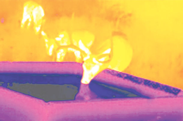 “Thermal cameras are very helpful for spotting animals during the day and night,” says Nick Franczyk, M.F.A. technology director at MPG Ranch.
Other devices being used to collect real-time data include weather stations, which monitor precipitation, temperature, and wind direction and speed. Soil moisture data loggers are also used to measure the moisture in the soil at varying depths.
Tracking devices can also be used for livestock to monitor grazing patterns and evaluate how livestock are using the landscape.
“The advantage of this system is: Once the wireless networks are established, virtually any device with a wireless signal can be tethered to the network and used for the producer,” Larkin says.
Even if a producer isn’t willing to experiment and add every possible device to a wireless connection, value can still be added with a simple camera system.
“That is easily valuable to a livestock operation,” Franczyk says. “Being able to see if a gate is shut or open, or check a water source without going to look at it reduces labor for a producer.”
Larkin also mentions the “smile” factor of setting up a basic camera system.
“If you set up a camera anywhere, you are going to see things you normally don’t see when you are physically in the area,” Larkin says. “This can include wildlife, or even things that haven’t been significant before, and that has the ability to make people happy.”
One issue producers face when bringing technology into their management system is the ability to organize and use the data being collected. Regardless of the settings of the cameras or the amount of devices collecting data, the amount of information collected adds up quickly.
Think Ubiquitous, a software company specializing in data comprehension, has developed a program called the Tellus Data Web Platform. Magdalena Donahue is a geologist currently working with the Tellus Data Platform.
“What we do is largely software building,” Donahue says. “Community data usage, comprehension and the application of that data are our focus. We want to build communities of people who want to use that data to their advantage.”
Donahue says the company is able to use data automatically collected from devices like cameras, or from an individual who is collecting the data themselves, and put it into a platform that is then put into a visualization that is interactive within your community.
“A community could be a single ranch that consists of a ranch owner, manager and other team members; the data would be put into a visualization so all of the members of the community can keep track of what’s going on as
far as data management,”
Donahue says.
A key portion of the Tellus Data Web Platform is: Once the data is put into the platform, it is all converted so it can be visualized, and it is entirely interactive. An example of this Donahue gave would be for groundwater measurements.
“If a producer has a map of groundwater measurements, and a logger beaming up the groundwater measurement every hour then, through the platform, you would be able to scroll forward and back through time to see a graph of a single well, or all the wells, and how it has changed through time,” Donahue says.
The platform can also incorporate atmospheric data such as rainfall or temperature and combine the information within the visualization. The information can then be shared with neighboring ranches, a soil conservation district or anyone the producer may choose.
The platform also has the capability to combine pictures with other data collected to form an augmented reality for the producer to observe. For example, if a producer took a picture facing due north, south, east, then west, from the same spot each month, the platform could create an augmented reality to observe the ecological effects over time.
Donahue says an advantage of the Tellus Data Platform is: It is completely scalable to fit an operation’s needs.
“We can put systems together that have different styles of data,” Donahue says. “The biggest advantage of using a system like this is: It’s totally scalable, so it can fit the needs of both small and large farms, and can be adapted to fit the budget of a certain operation.”
One advantage the company has to offer the producer is the ability to provide baseline data and pull in any information the producer collects.
“It allows you to be proactive in the management of your ranch,” Donahue says. “The ability to make really strong data-driven choices to protect your economic viability, but also care for your land from an ecological standpoint is a huge advantage.”
Fitting your current operation with cameras may not sound like an easy task, but the benefits could result in more than a few pictures. ![]()
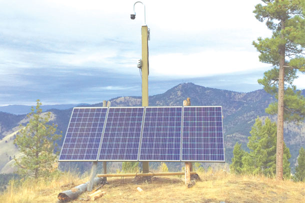
PHOTO 1: These are live-streaming video cameras. At MPG Ranch, they are typically mounted on a pole above a battery bank charged by solar panels. (The batteries had not yet been installed when this photo was taken.) Network connectivity is provided by a wireless mesh node. In the image, the camera is housed in the black ball on top of the pole.
Camera pan, tilt and zoom are user controlled via a user interface from the company website (livemap.mpgranch.com). The wireless mesh node is the gray box mounted on the pole below the camera. It points to the base station and transmits or receives data. The solar panel array is mounted on the A-frame, and the battery bank is usually housed in a plastic enclosure on the ground under the solar panels.
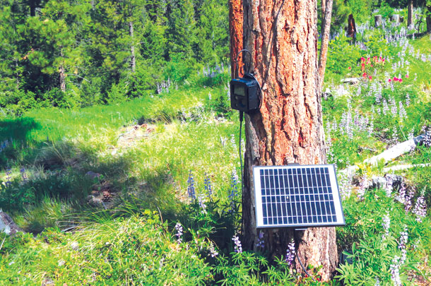
PHOTO 2: This image shows a still-image game camera with solar power and wireless data transmission capabilities. From the bottom, the solar panel is mounted on the tree. It charges a battery located in a small waterproof plastic box on the ground (not visible). Above the panel and to the left sits the camera. It takes images automatically when triggered by motion and thermal sensors.
An antenna is fixed above and to the right of the camera. The antenna transmits image data to the base station within a few seconds to a few minutes after image capture.
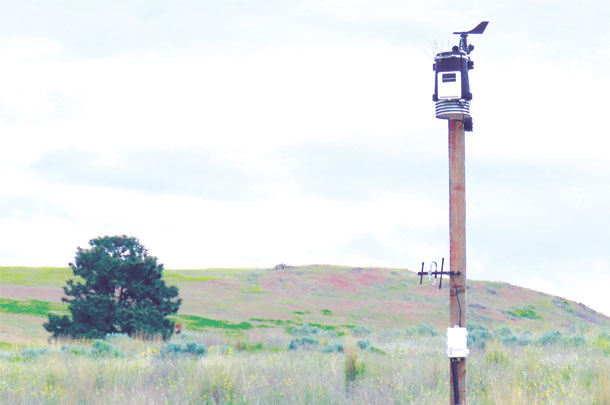
PHOTO 3: The weather station sits atop this pole and records air temperature, relative humidity, air pressure, wind speed, wind direction and rainfall. An antenna is mounted below the weather station and relays sensor data to the base station. Below the antenna sits a data logger for two soil temperature and two soil moisture sensor arrays. Each array has sensors buried at 6 inches and 36 inches deep. Photos by Gus Seward, MPG Ranch.
PHOTO 4: MPG Ranch also uses a few live-streaming cameras that record thermal data. This image shows a screen capture from a thermal camera mounted near a stock tank. Three mule deer are visible in this image. Thermal cameras help us find wildlife, particularly at low light or at night, and are also useful for security. Photo by Phil Ramsey, MPG Ranch.